Haight-Ashbury
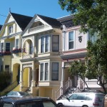
Known internationally for being the center of U.S. counterculture in the 1960s, the Haight-Ashbury developed from San Francisco’s barren hillsides as a streetcar suburb in the late 19th century and drew its name from what was then the main intersection. The neighborhood nearly survived the devastating 1906 earthquake intact, and it is home to one of the largest remaining collections of Victorian architecture in the city.
During the Great Depression, affluent families began moving to other city neighborhoods, and Haight-Ashbury transformed into a working class community. By the 1950s, the lower-income area became the target of city “urban renewal” efforts, including plans for a freeway cutting through the Panhandle park. Neighborhood residents formed the Haight-Ashbury Neighborhood Council in 1960 and successfully fought off renewal efforts, including the proposed freeway, by 1966.
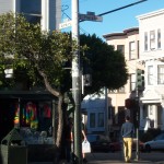
With social change occurring rapidly in San Francisco in the 1960s, Haight-Ashbury grew more diverse. Among residents attracted by affordable rents were a significant number of African Americans displaced by redevelopment in the Western Addition and a large student population attending San Francisco State College. By the late 1960s, the student population had led the neighborhood to become the center of San Francisco’s, and subsequently the nation’s, emerging youth counterculture.
 In the early 1970s, many young people left the city, and a number of storefronts and residential properties in the area went vacant. Haight-Ashbury saw an influx of hard drugs and a rising number of persons with untreated substance addictions. In the 1980s, the closure of state mental health facilities displaced many persons with untreated mental health issues and forced them out onto the streets, including the streets of Haight-Ashbury. The neighborhood became an important center of social services in San Francisco. The Haight-Ashbury Free Clinic, which began providing free medical care to those without insurance in 1967, started its detox program in the early 1970s. The Haight-Ashbury Food Program, established in 1983, and the Hamilton Family Shelter, established in 1985, provided for those in the neighborhood whose most basic needs were going unmet.
Today, vacant storefronts on Haight Street are gone, and today the neighborhood thrives with tourists, pilgrims, and locals alike.
Cole Valley
Located in the southwest quadrant of the greater Haight-Ashbury neighborhood, Cole Valley is anchored by a small business district of cafes, restaurants, and gourmet shops surrounding the intersection of Carl and Cole Streets. Since 1928, the Sunset Tunnel has provided rapid transportation between the intersection and downtown via the MUNI N line. Only a few, level blocks separate the area from Haight Street, yet Cole Valley maintains its own character and identity.
Adjacent to the business district, single-family residences line the slopes of Mt. Sutro, Buena Vista Hill, and Twin Peaks. The University of California, San Francisco (UCSF) lies to the west of Cole Valley and brings many doctors, medical students, and other health care professionals into the neighborhood. The Mt. Sutro Open Space Reserve, part of the UCSF campus, provides 61 acres of hiking trails, dunes, and forest habitat for San Francisco residents, visitors, and wildlife.